Groundwater
The upper layers of Earth’s crust are rich in a variety of resources, including stores of water known as aquifers. A common misconception is that aquifers are underground rivers or lakes; actually, an aquifer is an area of soil or porous rock that is saturated with water. Aquifers can be confined, meaning that there is an impermeable rock layer above the water preventing it from flowing to the surface, or unconfined, where there is no restriction on water flowing to the surface. The top of an unconfined aquifer is called the water table; where the water table meets the ground surface it creates a natural spring and/or can feed streams and rivers.
In some instances, water in a confined aquifer can be at a higher pressure than Earth’s normal air pressure, meaning that if you tap into the aquifer the water will naturally flow out. This is known as an artesian aquifer. Read more about aquifers.
It’s important to note that many aquifers are recharged by surface waters like rivers or rainfall seeping into the soil. However the recharge rate varies significantly, so it’s important that groundwater levels are monitored and groundwater use licenses varied accordingly. As aquifers may stretch across multiple shires, regions, and even states, this can require significant coordination between different authorities, but is key to sustainable management of this semi-renewable resource.
Alternatively, in cases of groundwater overuse, the aquifer can be recharged with purified recycled/reclaimed water (see below). This strategy is being applied in many places worldwide, for example Perth and California.
Our local aquifers
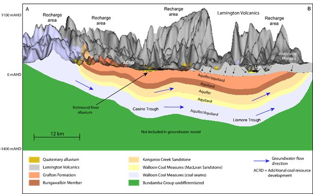
There are two key aquifers that you may have heard of in the Northern Rivers’ water options discussions. Both are located under the Alstonville plateau: one shallow aquifer, and a second much deeper aquifer. Only the shallow aquifer is currently in use, with groundwater extracted for irrigation and agriculture. The shallow aquifer is also an “emergency supply” for Rous County Council.
As per the motion passed on 16 December 2020 by Rous County Council, Rous will explore the viability of accessing the deep aquifer in Alstonville as an interim or temporary option while other smart water options are rolled out. As the aquifers are thought to be unconnected, this will have no impact on the available water in the shallow aquifer. The aquifers are thought to be unconnected, although further studies must be conducted to ascertain potential connectivity. If Rous County Council develops the deep aquifer as an interim additional water source, this will remove competition for the shallow aquifer during drought, which will benefit farmers.

The diagram above is a cross-section model of Richmond river basin, highlighting aquifer geometry, relative thicknesses of aquifers and aquitards. Source: Bioregional Assesments
